The general intent of the project is to scientifically test the capability of a low-capital cost improvement as a means of optimizing the "people carrying capability" of a radial corridor from a CBD. For the project, the following five goals were identified:
- Minimize the peak hour congestion and accidents within the I-35W corridor.
- Optimize the "people carrying" capability of the I-35W corridor.
- Ensure that this project's results are applicable to other urban corridors here and elsewhere.
- Respond to the socio-economic needs of the residents and users of the corridor.
- Test the bus on metered freeway system as a fast link element within the family of vehicles concept.
The purpose of this report on the Department of Transportation (DOT) concept and its acceptance and implementation by growing numbers of states is to assist in fulfilling the Task Force charge to "study the transportation needs of the State and devise plans for the future which shall encompass all modes of transportation." A D.O.T. organizational structure should by its very nature encompass all modes of transportation and could, if so organized, accomplish coordinated and integrated planning and administration of all modes.
In this report the attempt is made to provide Task Force members with factual data regarding the status of State DOT development nationwide and with a substantive analysis of the organizational structure, mechanics, performance, and problems of states with DOT experience. It is hoped that this analysis will assist the Task Force in evaluating the desirability of recommending the establishment of a State level DOT, in order to assist in achieving coordinated, comprehensive, statewide transportation planning in Minnesota
This document was created in response results of the Minnesota Highway Planning Survey. The survey was in response to the Hayden-Cartwright Federal Aid Act of 1934, which authorized federal funds for state transportation planning surveys. The Minnesota Highway Planning Survey revealed issues with the Road system, and this document attempts to explain and justify them.
This photograph shows the fountain and the beehive fireplace at Graeser Park Historic Roadside Property circa 1940. The fountain is no longer in operation.
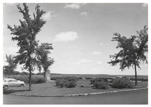
This black-and-white photograph shows the central island of the Garrison Concourse Historic Rest Area. Benches, cars, and the flagpole are visible in the background.
This black-and-white photograph shows Garrison Concourse Historic Rest Area circa the 1930s. Lake Mille Lacs is visible in the background, and both the wall and the water level are much lower than they are in the present day.