The graphs and reports in this booklet depict summaries and totals of the bridges in Minnesota as of July 1, 1995.
The four sections to the booklet are as follows:
1. General information of all bridges.
2. Deficient Structures - 10' to 20' in length.
3. Deficient Structures - 20' and over in length.
4. State Bridge Bonding Program.
Unless otherwise stated, the data represents all structures 10 feet and over in length.
The graphs and reports in this booklet depict summaries and totals of the bridges in Minnesota as of July 1, 1994.
The four sections to the booklet are as follows:
1. General information of all bridges.
2. Deficient Structures - 10' to 20' in length.
3. Deficient Structures - 20' and over in length.
4. State Bridge Bonding Program.
Unless otherwise stated, the data represents all structures 10 feet and over in length.
The graphs and reports in this booklet depict summaries and totals of the bridges in Minnesota as of July 1, 1988.
The four sections in this booklet are as follows:
1. General information of all bridges.
2. Deficient bridges - 10 foot to 20 foot in length.
3. Deficient bridges - 20 foot and over in length.
4. Bridge bonding program.
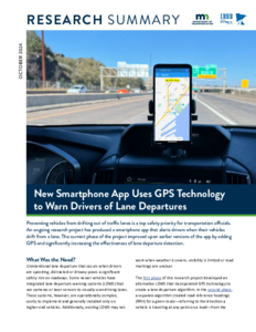
This Research Summary is part of Report 2024-25, "Development of a smart phone app to warn the driver of unintentional lane departure using GPS technology."
Unintentional lane departure is a significant safety risk. Currently, available commercial lane departure warning systems use vision-based or GPS technology with lane-level resolution. These techniques have their own performance limitations in poor weather conditions. We have previously developed a lane departure detection (LDD) algorithm using standard GPS technology. Our algorithm acquires the trajectory of a moving vehicle in real-time from a standard GPS receiver and compares it with a road reference heading (RRH) to detect any potential lane departure. The necessary RRH is obtained from one or more past trajectories using our RRH generation algorithm. This approach has a significant limitation due to its dependency on past trajectories. To overcome this limitation, we have integrated Google routes in addition to past trajectories to extract the RRH of any given road. This advancement has been incorporated into a newly developed smartphone app, which now combines our previously developed LDD algorithm with the enhanced RRH generation algorithm. The app effectively detects lane departures and provides real-time audible warnings to drivers. Additionally, we have designed the app's database structure and completed the programming of the necessary algorithms. To evaluate the performance of the newly developed smartphone app, we perform many field tests on a freeway. Our field test results show that our smartphone app can accurately detect all lane departures on long straight sections of the freeway irrespective of whether the RRH is generated from a Google route or past trajectory.
Systems Thinking is the fifth discipline identified by Peter Senge in his book "The Fifth Discipline: The Art and Practice of the Learning Organization." An organization, or a group of people, that encompasses all five disciplines enables participating individuals to orient themselves within complex systems and to grow together as a learning team.
This project was a response to the Commissioner of Transportation's directive to broaden the Minnesota Department of Transportation's (Mn/DOT's) research investment to include the development of policy. The Office of Research Administration (ORA) adopted a System Thinking approach to defining and exploring how the Commissioner's directive could best be implemented.
The charge to the task force included an expression of concern over the appropriate mission of R & D in Mn/DOT, its placement within the organizational structure, and its physical location with respect to operating effectiveness and access to facilities. The charge further quoted Commissioner Braun's concern for needing more direction in certain areas before he could implement the RETAF recommendations for R & D
This prospectus outlines the need for and nature of a system of freeway surveillance and control for the St. Paul-Minneapolis Metropolitan Area. Information is presented on the transportation trends in the Metropolitan Area showing heavy reliance on highway vehicular travel and indicating that capacity deficiencies will exit. The role that freeway surveillance and control may play in the development of a total transportation system is presented. Also included is information on the cost-effectiveness of various urban transportation modes.
The long-range plans and a description of the ultimate system are outlined along with a plan of implementation to develop the system in an organized manner.
This report is the result of a project initiated by the Minnesota Department of Transportation (Mn/DOT), in which the University of Minnesota's Center for Transportation Studies (CTS) was asked to involve key stakeholders in investigating options and making recommendations for the future governance of the MnROAD test facility. A task force appointed by Mn/DOT and CTS worked with CTS and consulting staff to develop the recommendations contained in this report.
This report summarizes the information considered by the Task Force in arriving at recommendations in response to its charge from Mn/DOT Deputy Commissioner Douglas Differt. The findings and opinions expressed are those of the Task Force and