To support snowplow operators in low-visibility conditions, a snowplow driver-assist system was developed to provide the driver with lane guidance and forward obstacle detection feedback. The guidance system used a real-time kinematic global navigation satellite system receiver and high accuracy digital maps of the roadway to communicate lateral positions of the snowplow to the driver.
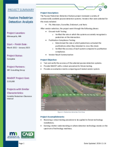
The Passive Pedestrian Detection Analysis project reviewed a variety of commercially available
passive detection systems. Vendors that were selected for this study included:
• Flir, Miovision, Econolite, Gridsmart, and Iteris
After vendor selection, the project went through the following phases:
• Ground-truth Testing:
o Verified the rate at which the systems accurately recognized a pedestrian at the intersection.
• Pushbutton Compliance Testing:
o Determined the rate at which pedestrians activated the pushbuttons when they intended to cross
the street.
o Verified the accuracy of each system compared to pushbutton compliance.
• Vendor Result Summarization
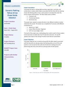
This project focused on utilizing high-resolution signal data, crash data, and volume data to analyze safety impacts associated with the three left-turn phasing modes that flashing yellow arrows could operate in and determine when the various modes should operate. The three modes were as follows:
• Protected only.
• Protected-permissive.
• Permissive only.
The project team needed to analyze the data in two different methods to better understand the results. The analysis was completed for 9 scenarios with different combinations of:
• Speed (Low / High)
• Lateral Offset (Positive / Negative)
• Left-Turn Lane (Single / Dual)
The result of this project was a methodology that could be used for future analysis and incorporation of safety data into FYA operations decisions. No specific updates were made to the existing FYA phase mode decision spreadsheet.
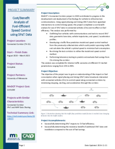
MnDOT’s Connected Corridor project in 2020 contributed to progress in the development and deployment of technology for vehicle-to-infrastructure communications. Using signal phasing and timing (SPaT) data from signalized intersections to control driving speed, this project completed a cost benefit analysis for use of SPaT data in connected vehicles (CVs) and its effect on fuel efficiency. The analysis was performed by:
• Outfitting four vehicles with communications and tools to record SPaT data, geometric lane data, vehicle trajectories, and speed / acceleration profiles.
• Developing a traffic flow prediction model and speed control method from the previously collected data which could predict upcoming traffic and calculate the vehicle’s optimal speed to minimize fuel consumption.
• Re-driving the test corridors to refine the model and speed control method.
• Performing laboratory testing to predict and evaluate fuel savings from CVs driving the corridor.
The analysis was completed for diverse traffic scenarios at different CV market penetrations ranging from 10% to 90%
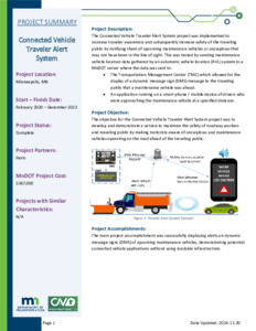
The Connected Vehicle Traveler Alert System project was implemented to increase traveler awareness and subsequently increase safety of the traveling public by notifying them of upcoming maintenance vehicles or snowplows that may not have been in the line of sight. This was tested by sending maintenance vehicle location data gathered by an automatic vehicle location (AVL) system to a
MnDOT server where the data was sent to:
• The Transportation Management Center (TMC) which allowed for the display of a dynamic message sign (DMS) message to the traveling public that a maintenance vehicle was ahead.
• An application running on a smart phone/mobile device of drivers who were approaching the maintenance vehicle at a specified distance.
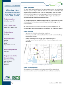
The Bear Tracks Automated Shuttle Pilot was a research project that included the 12-month operation (August 2022-July 2023) of a Level 3 Automated Vehicle (AV) Shuttle along a 1.5-mile-long route in the city of White Bear Lake. The shuttle itself was a self-driving, electric, multi-passenger vehicle that drove at a speed between 10-12 miles per hour. The shuttle could hold up to 11 seat-belted passengers and one wheelchair passenger at a time.
The shuttle's route along a residential street connected a day program for adults with intellectual and developmental disabilities, affordable housing, and the community YMCA.
The demonstration was concluded before the projected end date due to the restructuring of the vehicle manufacturer and resultant lack of technical support.
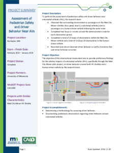
To perform the assessment of pedestrian safety and driver behavior near automated vehicles (AVs), the research team:
• Observed the surrounding environment as passengers on the Med City Mover shuttles (low speed, level 4, automated vehicles) and as passengers in a human-driven vehicle following the same route.
• Completed two loops or circuits around the demonstration route for each observation period.
• Completed a total of 22 loops of observations within the Med City Mover vehicle and a total of 14 loops of observations in the human-driven vehicle.
• Recorded data about observed driver behavior as well as locations that said driver behavior occurred.
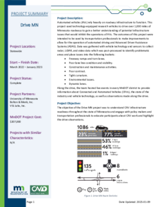
Automated vehicles (AVs) rely heavily on roadway infrastructure to function. This project used technology-equipped research vehicles to drive over 1,000 miles of Minnesota roadways to gain a better understanding of potential infrastructure issues that would inhibit the operations of AVs. The outcomes of this project were intended to be used by transportation professionals to make improvements to allow for the operation of automated driving and Advanced Driver Assistance Systems (ADAS). Data was gathered with vehicle technology and sensors to collect radar, LiDAR, and video data which was post-processed to identify problematic areas and place issues into the following buckets:
• Freeway ramps and turn lanes.
• Poor lane line condition and visibility.
• Construction and maintenance activities.
• Poor contrast.
• Tight curvature.
• Environmental issues.
• Dynamic lanes.
Along the drive, the team hosted live events in every MnDOT district to provide information about Connected and Automated Vehicles (CAVs), the state of the industry and vehicle technology, as well as observations made along the drive.
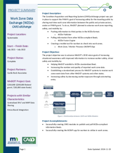
The Condition Acquisition and Reporting System (CARS) eXchange project was put in place to support the FHWA's goal of increasing safety for the traveling public by sharing real-time work zone information between the public and private sectors, under an FHWA grant. To do so, MnDOT planned to advance work zone reporting, safety, and mobility by:
• Pushing information to third parties in the WZDx format: WZDx Publisher
• Pulling information from other WZDx-compliant feeds: WZDx Fusion Engine
• Creating a mobile tool for workers to check into work zones: Work Zone / Worker Presence (WZWP) App
The Smart Snelling project was comprised of two main components:
• Testing a third-party application to provide users signal phasing and timing (SPaT) information.
• Testing snowplow signal priority.
MnDOT and Ramsey County installed connected vehicle technology equipment at 16 intersections owned by MnDOT and Ramsey County. The project tested the equipment’s ability to provide snowplow signal priority by communicating with the onboard unit on the plow truck. The project also tested the “TravelSafely” mobile phone application’s capabilities to provide real-time information accurately and effectively about signal phasing and timing to inform travelers of phase changes, red-light running, and presence of pedestrians/cyclists.