Many DOTs struggle with real-time information being relayed to their users in situations that involve lane closures. Due to the variability in location and duration, real-time integration of arrow board messages into traveler information systems became an item of interest for MnDOT to provide up-to-date data to travelers. This project involved:
• Deployment of an integrated ITS solution to report on the location and operational status of arrow boards in real time to MnDOT's Regional Transportation Management Center (RTMC) systems.
• Integration of the arrow board status information with the MnDOT Intelligent Roadway Information System (IRIS) to alert RTMC operators of lane closures who could then add messaging to nearby dynamic message signs.
• Integration of the arrow board status information with the MnDOT Condition Acquisition and Reporting System (CARS) which provided real-time updates to the traveler information system.
The pilot project involved 20 arrow boards equipped with the status monitoring unit to test displaying real-time information to travelers related to stationary and mobile lane closures.
The Variable Pedestrian Clearance Interval (VPCI) project consisted of deploying, testing, and analyzing the results of installing video at an intersection to extend the Flashing Don't Walk (FDW) interval as needed when pedestrians were still located within the crosswalk. To complete this project, the project team:
• Installed pedestrian detection equipment.
• Reviewed an initial round of testing data to find gaps in the system data.
• Determined a new path forward after identifying the data gaps.
• Tested additional pedestrian detection equipment.
• Utilized ATSPM data to verify the outcome of the pilot.
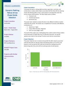
This project focused on utilizing high-resolution signal data, crash data, and volume data to analyze safety impacts associated with the three left-turn phasing modes that flashing yellow arrows could operate in and determine when the various modes should operate. The three modes were as follows:
• Protected only.
• Protected-permissive.
• Permissive only.
The project team needed to analyze the data in two different methods to better understand the results. The analysis was completed for 9 scenarios with different combinations of:
• Speed (Low / High)
• Lateral Offset (Positive / Negative)
• Left-Turn Lane (Single / Dual)
The result of this project was a methodology that could be used for future analysis and incorporation of safety data into FYA operations decisions. No specific updates were made to the existing FYA phase mode decision spreadsheet.
The Smart Snelling project was comprised of two main components:
• Testing a third-party application to provide users signal phasing and timing (SPaT) information.
• Testing snowplow signal priority.
MnDOT and Ramsey County installed connected vehicle technology equipment at 16 intersections owned by MnDOT and Ramsey County. The project tested the equipment’s ability to provide snowplow signal priority by communicating with the onboard unit on the plow truck. The project also tested the “TravelSafely” mobile phone application’s capabilities to provide real-time information accurately and effectively about signal phasing and timing to inform travelers of phase changes, red-light running, and presence of pedestrians/cyclists.